Monday, December 25, 2017

Increasing sea surface temperatures and decreasing deeper ocean warming

As I expected there is a correlation between wind and rainfall. More wind then more rainfall. See
http://journals.ametsoc.org/doi/full/10.1175/JCLI3519.1
I propose that my idea of floating spray pumps, to create a spray mist on the sea, will have a similar effect as more wind. The spray mist will keep in heat radiated by the sea when sea is warmer than air and will generally tend to increase sea surface temperatures on clear nights. This will increase humidity and the chances of rain. Fortunately, during sunny days, the mist will prevent solar radiation from entering the sea and warming deeper levels of ocean.
Generally the mist will increase evaporation and enhance chances of rain. It will absorb solar energy during the day and heat up, again increasing chances of rain.
See also https://www.facebook.com/groups/RainSeaVsAirT/

Wednesday, December 13, 2017

Power coastal cities and cool oceans

Here is a way to provide power to cities on the coast and to cool the oceans to combat global warming. Usually the sea is warmer than the air at night. So at night use solar updraft towers, but pump heat, using a heat pump, from the sea to seawater in the solar updraft towers to heat and humidify the air in the solar updraft towers at night. Say the sea temperature was at Tsea=15 deg C and the seawater and air temperature in the solar updraft tower was 18 deg C after warming. Suppose the outside air temperature was 10 deg C. Then the heat pump would be very efficient and the air temperature difference between inside and outside the solar updraft tower would be in a nice range to start with. The heat pump could be powered by wind energy. During the day use the standard greenhouse at the base of the solar updraft tower to heat seawater in the tower to heat and humidify the air. The humid air will increase chances of rain and the clouds will reflect solar energy to space, cooling Earth. Have had a look at Greenland. It seems very suitable for this method. Ocean near the Arctic region could be cooled using this method. See
See
https://en.wikipedia.org/wiki/Solar_updraft_tower
See the the Carnot heat pump formula.at
 http://hyperphysics.phy-astr.gsu.edu/hbase/thermo/heatpump.html
TH=291.15 kelvins. TL=288.15 kelvins

 COP=291.15/(291.15-288.15)=291.15/3 = 97.1

Saturday, December 9, 2017

Long greenhouse method to bring rain.

One could have a greenhouse to evaporate seawater near the sea and have a long greenhouse (or "greenhouse pipe") running upwards to where the dam areas are. Because the air will be kept warm during the day in the greenhouse pipe and moist air is less dense than drier air, the air will rush up through the greenhouse pipe and heat the dry air region and increase relative humidity there. Now it might seem that this would have little effect, but this system could be kept running day and night throughout the year. From my "stack effect" calculations quite a few cubic kilometres of warm moist air could be delivered every week to higher regions. The slight increase in relative humidity could just tip the balance enough to help it rain significantly more.
 More humid air is less dense than drier air, enabling it to rise when it is at the same temperature as  surrounding drier air: 
Example: 
1) At sea level the air pressure is 101.325 kPa. The air has a temperature of 30 deg C and the relative humidity (RH) is 95%. Then the density of the air is 1147 g per cubic metre.
2)  At sea level the air pressure is 101.325 kPa. The air has a temperature of 32 deg C and the relative humidity (RH) is 50%. Then the density of the air is 1147 g per cubic metre.
So humidifying the 30 deg C air by increasing RH from 50% to 95% has about the same affect on air density as heating the RH=50% and T=30 deg C air to T=32 deg C. 
Note: RH drops slightly on heating from 30 to 32 deg C, but it does not affect calculations much.

Tuesday, November 28, 2017

Rain when sea temperatures are greater than minimum air temperatures

Cape Town is one city where the minimum (night) temperatures are generally colder than the sea temperatures (see photo). This means that if you can create a spray over the sea with floating spray pumps at night you will have this situation: The warmer sea will have a spray "mist cloud" of low elevation over the sea. This cloud will capture radiation from the sea (greenhouse effect, with sea hotter than air above) and warm up, because clouds are good absorbers of infrared radiation. So at night the air will become warm and humidified. During the next day the land will heat up and a sea breeze will develop (at about midday). The warm moist air will blow onto land and the hot land will heat this moist air from below, increasing chances of rain. I am trying to get other countries interested in this concept, so perhaps South Africa will be able to observe what happens in other countries. 
See http://www.asterism.org/tutorials/tut37%20Radiative%20Cooling.pdf to gain insight to the radiation effect from the sea.
Many cities have this property.
See photo for Cape Town below.

Note that sea spray is natural and occurs in massive amounts when wind blows over the sea.

Tuesday, November 14, 2017

Water from seawater

Here is a method to make clean water from the sea: Geothermal heat pumps use ground as a heat sink. The air is cooled above and the heat pumped to the ground. 
To make clean water have a huge steel cylinder above the sea. Cool the steel using a heat pump that takes heat from the steel cylinder and puts the heat into the water. The heated water will evaporate into the steel cylinder and so the process will continue with water vapour condensing on the cool steel where it is collected. Solar energy could be also be used to heat the water below the steel cylinder. See https://en.wikipedia.org/wiki/Direct_exchange_geothermal_heat_pump
If a lot of solar energy were used to heat the water below the steel cylinder the heated water could also add more moisture to the surrounding air to slightly increase chances of rain.

Heat pumps are very efficient - you can get about 4 units of cooling with 1 unit of power. Wind, wave energy and batteries could be used to power the heat pump.
 If the air temperature inside the cylinder were 100 deg C and the cylinder walls were at a temperature of 80 deg C, the cylinder would cool by radiating heat and by being in contact with cooler air on the outside. This would enable increased condensation of water vapour on the cylinder walls.
Imagine a small scale system like this. If you use 1 kW of power to cool the cylinder you could get about 4 kW of cooling. So say you run it for an hour. Then you get 4kWh of cooling. It takes roughly 0.7 kWh to condense out a litre of water, so you should get about 4/0.7=5.7 litres an hour using power of 1 kW (assuming a coefficient of performance (COP) of 4). Note that as the water of the water heat sink evaporates it cools, making the system more efficient.

This whole system could be used in reverse to cool the sea and heat air in the cylinder. If the air were heated and seawater were sprayed in at the bottom, one could also create hot humid air and release it to the surroundings to increase chances of rain. One would need a huge cylinder and a lot of power to have a marked effect. With wind, wave and solar power it could work. Fortunately heat pumps do a lot of cooling or heating with a small amount of power (COP=4 or so).

COOLING THE SEA: If you can create cloud to shade the sea you can cool the sea down. Here is a method that will directly cool the sea and will cause convection above the sea by heating air above the sea. This will cause more clouds and rain. Rain cools the sea surface because it comes from cool regions higher up. Method: Use a heat pump to take water from the sea (sea is the fridge) and place it in some air cooled metal heat sink above the sea (fins of the fridge). The fins will warm the air causing upwards convection of warm air causing clouds and rain. Wind power could be used to power this heat pump. Heat pumps are very efficient and you can get about 4 units of cooling for 1 unit of input power - see https://en.wikipedia.org/wiki/Geothermal_heat_pump
Another desalination method I came across: https://atmocean.com

Monday, November 6, 2017

Green parties could play the blues

Green parties could play the blues to solve global warming: In some places daylight persists much longer than at other places and near the Arctic circle one has very long days in summer and phytoplankton must have adjusted to this. Phytoplankton remove huge quantities of carbon dioxide from the atmosphere by using green and blue light to flourish. The phytoplankton is harmed by ultraviolet light and so here I propose a global warming solution:
At night, when there is virtually no ultraviolet light, irradiate the ocean with green and blue light, that penetrates the night, reducing CO2 as revellers delight. The ocean could be irradiated from green and blues lights on tall poles on land while people dance on the sand. This would create an attraction, inviting to the rich tourist faction.
Would flashing green and blue lights harm the phytoplankton though? I am hoping the concept can be implemented on coastlines extensively.
See https://www.whoi.edu/oceanus/feature/shedding-light-on-light-in-the-ocean

Tuesday, October 31, 2017

Rain producing ideas.

1) Use wind energy to heat air at night for rain: When temperature drops at night the relative humidity increases. Just look at Internet weather reports and you will see that this is a regular occurrence. For dry areas, why not have greenhouses with rocks in to absorb solar energy during the day and use electrical energy from wind power (wind turbine, etc) at night to heat the air and rocks in the greenhouse so that high relative humidity air can be heated and rise to form convectional rain? Drought is costing billions and it would be worth spending millions on enhancing chances of rain. One would need some method of letting the hot air out of the greenhouse at night. It does not take much heat energy to heat a lot of air.
2) From the Internet I read that the sea temperatures at Los Angeles in Jan and Feb are about 14.5 deg C. The average minimum air temperature for Los Angeles is about 9.2 deg C. At night, if one had a pipe inlet with a big collection area just above the sea the air temperature of the air coming into the pipe would be about 5 deg C warmer than the air temperature above the city. This means natural upwards convection of relatively warm moist sea air could occur in the pipe. If the pipe were coated with a low emissivity surface (shiny aluminium, etc) it would retain heat. It seems quite possible that convectional rain could occur with enough big pipes leading from the sea to over the city.
This idea might not work all of the time because air pressures over the sea and land might be different, but here are some points:. 1) The air just over the sea will be warmer and therefore less dense 2) The air from just over the sea will be moist and moist air is less dense. 3) For some periods it will work.
This calculation would be suitable for Cape Town: I use the Engineering Toolbox stack formula, with the following: A 20 m radius pipe (huge) Inside T of 14 deg C. Outside T of 8 deg C. This gives a flow rate of more than 1 cubic kilometre of air per 24 hour day, so the amount will be less, but it is a large volume of air.

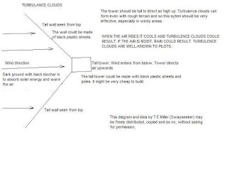
3) If you look at the pdf called Pilot Exam Notes Meteorology on the internet you will see, on page 10, a discussion of turbulence clouds. Turbulence clouds can form when rough terrain funnels air upwards. As the air rises it cools and clouds can form. My system uses biochar to absorb solar energy and heat air and channels the air upwards. With even light wind and some sun rain could result.
4) The wind speed is low just over the ocean (as it is just above the ground). There is therefore a fairly stagnant layer with very high relative humidity just above the sea. If one used thousands of floating devices as shown below one could increase moisture in the air so that air blowing to land would produce more rain. Water has a very high emissivity (about 0.95), so the greenhouse plastic will keep in a lot of radiation from the sea surface. For high sea surface temperatures of 30 deg C or so, the greenhouse will keep in about 450 W per square metre of infrared radiation from the sea surface.

The light portion of the solar energy passing through the greenhouse plastic will be absorbed by the black sheet instead of it penetrating deep into the ocean. The infrared portion of solar energy entering the greenhouse will be absorbed within the uppermost few centimetres of the sea surface. Any infrared radiation from the sea that is reflected back to the sea by the greenhouse plastic will also be absorbed in the upper few centimetres of the sea. The result will almost certainly be a heating of the sea surface under the greenhouse plastic, enhancing evaporation and high humidity. About 53% of solar energy is light energy, so the black sheet will prevent a lot of energy from escaping down to deeper levels and will concentrate it near the surface.


Wednesday, September 27, 2017

Creating rain using convergence of sea breezes

Some people will know more than me about sea breezes around Cape Town than I do, but Florida and other narrow land masses have sea breezes from both sides and there is an area of convergence where high pressure and rising air result where the two breezes meet. This is associated with high rainfall in areas such as Florida. Could one heat the middle of the Cape Peninsular by using biochar? The dark biochar soil will heat up more than the surrounding land and air above it will rise. Could this result in a situation similar to those they have in other areas of convergence, such as Florida? The sea round Cape Town is not as hot as the sea round Florida, but I bet one could increase rainfall by making land darker in the middle of the land area. Convergence and rain also occurs in New Zealand - see http://blog.metservice.com/SeaBreezes 
See also http://climate.ncsu.edu/edu/k12/.liftingmechanisms 
In summer in Florida rain occurs daily during some periods. A sea breeze is created by hot rising air over the land, wind blows in from both sides (two sea breezes) and the two air masses collide. Pressure is created where they collide and the air has only one place to go and that is upward. This rising air creates the frequent convectional rain mentioned. 

To dry out the air so that less hurricanes are formed in the Gulf of Mexico, put wide strips of solar air heaters in the Gulf to imitate a sort of very narrow Florida and create convectional rain that way to dry the air. The phenomenon of drying out of the air in tropical regions, because of frequent convectional rain, is discussed in "Understanding the sky" by Dennis Pagen - it can be found on the Internet - see https://www.google.co.za/url?sa=t&rct=j&q=&esrc=s&source=web&cd=1&cad=rja&uact=8&ved=0ahUKEwi_yt7fm8fWAhWBCMAKHbTnDDsQFggnMAA&url=http%3A%2F%2Fblog.rodbailey.com%2Fuploads%2FDennisPagen-UnderstandingTheSky.pdf&usg=AFQjCNEGUkY7t2VnkKagFH3NKNXtHDys7g

The United Kingdom has various air masses moving onto it. 1) Polar maritime air that has blown over the sea and is cold and moist. 2) Polar continental air that is cold and dry 3) Tropical maritime air that has blown over the ocean and is warm and moist 4) Tropical continental that is warm and dry 
 Question: Which of the above do you think brings both showers and thunderstorms?
 Answer: Although warm moist air holds a lot of moisture, when warm moist air is heated from the ground or ocean (this is the usual way air is heated - it is heated from below), it is not much warmer than the air above it (or the sea may be colder and cool the air from below) and not much upward convection (or no upward convection) occurs. With the cool moist polar maritime air (1 above), the air heated by the ground or ocean is hotter than the air above it and rises, so case 1 is the only option that provides both showers and thunderstorms (Reference: Aviation Law And Meteorology by Air Pilot Publishing Ltd).

Could one create rain using floating spray generators in the sea to humidify the air and floating solar air heaters to heat the moist air and cause convectional rain?
Example: Suppose sea and air temperature above the sea and over land is 20 deg C. Suppose the relative humidity (RH) is 60%. Then the wet bulb temperature is 15.21 deg C. If we assume fine mist evaporative cooling with an efficiency of 80%, then the evaporation of spray will cool the air down to 16.17 deg C. This is 3.83 deg C lower than the 20 deg C. With sea at 20 deg C and air at 16,17 deg C the air can be heated from below by the sea. This would simulate the situation in option 1. I calculate that 1.9 g of water needs to be evaporated into every cubic metre of air to result in a temperature lowering of 3.83 deg C. If the spray generators were permanent, a cooler micro-climate would result, but sea temperatures would stay more constant and convectional rain should occur. Calculating relative humidity (RH) after an 80% efficiency fine mist cooling, I get that RH=90% after evaporation. With such a high RH, if you heated an air parcel 2 deg C to 18.17 deg C, it could rise 606 m by virtue of being 2 deg C warmer, and it would only have to rise 456 m for cloud to start forming (used general sorts of lapse rates).
Previously I mentioned that when the sea was hotter than air temperatures, then from graphs, rain was more likely. This makes sense because then the air is heated from below by the sea, it will rise into the colder air and keep rising until it is at the same temperature as the surrounding air, and convectional rain should occur.

 AIR POLLUTION: I will quote you something from Aviation Law and Meteorology by Air Pilot Publishing LTD. It talks about rising air (which will result when solar air heaters heat air). "In a depression , the rising air will be cooling and so cloud will tend to form. Instability in the rising air may lead to quite large development of cumuliform cloud accompanied by rain showers. Visibility may be good (except in the showers), since the vertical motion will tend to carry away all the particles suspended in the air."

Friday, September 15, 2017

Cool Earth Using Evaporation

https://www.ess.uci.edu/~yu/class/ess55/lecture.2.thermodynamics.all.pdf says,
"�Earth’s surface lost heat to the atmosphere when water is evaporated from oceans to the atmosphere. �The evaporation of the 1m of water causes Earth’s surface to lost 83 watts per square meter, almost half of the sunlight that reaches the surface. �Without the evaporation process, the global surface temperature would be 67°C instead of the actual 15°C."
I am trying to convince scientists to implement the use of floating spray pumps to create evaporative fine mist cooling over the Gulf of Mexico and regions where the tropical storms form. It will prevent solar energy from entering the ocean and cool, preventing hurricanes from forming.To get convection and convectional rain, solar air heaters can be used to heat the moist air - I think it will save insurance companies billions. The whole mechanism of rain (evaporation and condensation) moves energy away from the surface to regions higher up.
https://www.sciencedaily.com/releases/2011/09/110914161729.htm explains that evaporation increases low level clouds which reflect solar energy back to space. In fact low level clouds in low latitudes are comparatively warm and radiate heat back to space better than other clouds. Some scientists used to believe that more evaporation could even warm Earth because water vapour is a greenhouse gas. When they fed extra evaporation into climate models it showed that evaporation cools Earth.

Are warming sea temperatures making hurricanes worse?

One sees constant discussion about whether global warming is making hurricanes worse. There is a lot of rain with hurricanes, which means huge energy comes from the ocean. It takes about 2400 kJ to evaporate a kg (about a litre) of water and rain means there must have been evaporation in the first place. The energy for the evaporation comes almost entirely from the water, because air has such a small heat capacity that if the energy came from the air it would quickly be cooled. Air has a volumetric heat capacity of about 1.2 kJ per cubic metre for every 1 deg C drop in temperature. Water has a volumetric heat capacity of about 4180 kJ per cubic metre for every 1 deg C drop in temperature. 
http://www.aoml.noaa.gov/hrd/tcfaq/D7.html  tells us that a hurricane has about 5.2x10¹⁹ J or 5.2x10¹⁶ kJ of energy per day spread out over about an area with radius 665 km. My calculations give that this is about 37429 kJ per square metre per day or 10.4 kWh per square metre per day. By comparison one may get about 8 kWh per day per square metre from the sun (Weatherspark will tell you how much for you area). If the energy is coming from the water, then one cubic metre of water (1000 kg) would be cooled 37429/(4180)=9 deg C in a day. So if we do not have deep hot water to provide the energy, the hurricane will lose strength. It seems obvious that warming sea temperatures will fuel hurricanes more, or have I missed something?

Monday, September 4, 2017

Air pollution solution calculations.


Air pollution solution calculations : Many people do not realise that there is a sufficient amount of solar energy to heat massive volumes of air every day. The problem is getting air to come into intimate contact with hot surfaces. The ground heats air immediately above it, but there is not intimate contact with large volumes of air. Solar air heaters provide large hot surface areas and intimate contact. See http://www.builditsolar.com/Experimental/PopCanVsScreen/PopCanVsScreen.htm
Often about 7 kWh of solar energy fall on every square metre of surface in a day. This is 7x3600 kJ, which is 25200 kJ of energy. Air has a volumetric heat capacity of about 1.2 kJ/(deg C.cubic metre) and we might ask how many cubic metres of air we could heat by 5 deg C every day with the 25200 kJ? The answer is we can heat 25200/(5x1.2) cubic metres by 5 deg C in a day. We divided by 1.2 (volumetric heat capacity) and by 5 (the number of degrees the air is heated.). This is 4200 cubic metres that can be heated 5 deg C in a day by a 1 square metre solar air heater.This has great implications for diluting air pollution, for enhancing chances of convectional rain and for cooling cities. If we place a large number of solar air heaters above each other on a tall pole we could have massive heating of air.
 If the solar elevation angle is not 90 degrees, then we can do this without the one solar air heater casting a shadow on the one below. Only at midday, in equatorial regions, on two days a year, could we have a solar elevation angle of 90 degrees, so we can safely say it is possible not to have shadows cast on solar air heaters below, for the most part of the day and year, anyway. 
Another advantage of this is that we could cool cities like Kuwait city. Huge solar air heaters on the tall pole would shade parts of the city, the solar energy would go into heating the air, the air would rise and transfer heat to a higher altitude and Kuwait city would be cooler.
I had a hard time finding figures for the volumetric heat capacity of air. In fact I could not find a table so I made one.The figures will be useful for calculating how many cubic metres of air at a certain temperature and pressure of 101.325 kPa can be heated by a solar air heater, for example. 
I calculated the figures using Specific heat of mixture of gases=sum of (mass fraction x specific heat of each gas). I then calculated the mass of a cubic metre of air with RH=50% for various temperatures and multiplied specific heat by mass of a cubic metre of air with RH=50 and P=101.325 kPa at various temperatures. The RH makes very little difference to the volumetric heat capacity (although it does make a bigger difference to the specific heat in kJ/kg.degC.). For instance the volumetric heat capacity of dry air at 35 deg C at P=101.325 kPa=1.154 kJ/degC.m^3 and the volumetric heat capacity for an RH=50% parcel at the same temperature and pressure is 1.159 kJ/degC.m^3. 
The chart is for people living in cities on the coast. If you want a chart for your city, please give me altitude. If you want to do calculations on air pollution and convection then you can proceed as follows:
1) Find out how many kWh you receive in a day from Weatherspark Note that this Weatherspark figure is for a horizontal surface. If you let the solar air heaters face the sun you could get a lot more kWh of heat.
2) Decide on the area of your solar air heater and multiply (eg 100 sq metres and 6 kWh per sq metre per day. kWh=6x100=600 kWh. This is 600x3600 kJ (1 kWh=3600 kJ) ie this is 2160000kJ).
3) If you heat the air 5 deg C, then number of cubic metres heated in a day by 5 deg C = 2160000/(5xvolumetric heat capacity). You can get the volumetric heat capacity from the chart.
4) If the system is only 70% efficient, then multiply by 70/100=0.7.

Sunday, August 27, 2017

Preventing flooding

In the tropics strong solar energy creates strong convection. So you will find that rain occurs frequently in areas near the equator and this convection and frequent rain dries out the air (the water vapour becomes rain). This results in higher level clouds - Espy’s equation says that the height of cloud bases = 125 (temperature- dewpoint temperature). To explain, the dewpoint temperature is the temperature near ground level in this equation and the temperature is the ambient temperature near ground level. The answer is in metres. Now if you had solar air heaters on every rooftop and on poles in the cities, it is my belief that you would have far greater convection and more frequent rain. This would dry the air and prevent flooding, but you would often get rain in smaller amounts. One reference that discusses this phenomenon of frequent rain and higher level clouds is “Understanding the sky” by Dennis Pagen and it can be found on the internet. To build your own solar air heater see http://www.builditsolar.com/Experimental/PopCanVsScreen/PopCanVsScreen.htm

Thursday, August 24, 2017

Urban heat island effect and cool paints

A lot of people are asking about how the cool paint works. Looking at one photo, it appears fairly dark so the paint is absorbing some light energy. All components of sunlight, if they are absorbed, heat a surface. So untraviolet heats, visible light heats and infrared heats if they are absorbed. We cannot see the ultraviolet and we cannot see the infrared, so we do not know if they are being reflected instead of being absorbed by looking. If something is white we know it is reflecting the visible portion of sunlight (about 43% of the energy from the sun is visible energy).
http://www.pcimag.com/articles/86552-when-black-is-white may help. Green vegetation does shade and also does reflect infrared, so trees are a good option. I am an advocate of using solar air heaters on poles to shade streets. By the conservation of energy, if air is heated by solar air heaters, other objects can not be heated with the same energy (can either be in air or in the other objects). My understanding of this paint is that it reflects infrared. With an urban heat island effect, the sunlight (includes infrared and ultraviolet) enters the city and gets reflected around onto walls and so on. They absorb the sunlight to some extent and heat up. The sunlight coming in has mainly short wavelength. After buildings heat up they emit radiation of a longer wavelength. Some of this longer wavelength radiation will probably be reflected by the paint and some will go out to space. The infrared of sunlight is high frequency (short wavelenth ) infrared. The heated buildings emit longer wavelength infrared radiation, mainly. With white cool roofs some sunlight is reflected onto other buildings causing heat problems. One of the big problems can be windows with sunlight entering. Window glass transmits radiation up to about 2.5 microns (the energy goes through the glass if its wavelength is less than about 2.5 microns) and about 97% of solar energy has wavelength less than 2.5 microns, so virtually all enters via a window.
Now how much of this energy escapes? Well if the walls heats up to 50 deg C, then radiation from them that is above 2.5 microns will not escape. The answer is that far less than 1% of this radiation can escape through the glass because more than 99% of the energy radiated by the 50 deg C walls is of wavelength greater than 2.5 microns (using a blackbody approximation). If a particular cool paint does reflect infrared, where is the infrared radiation going to go? Remember angle of incidence= angle of reflection. One may note that green vegetation reflects solar energy of wavelength between 0.75 to 2.4 microns significantly. Most of this could be reflected through your window into your house (glass lets in radiation of wavelength less than about 2.5 microns). This radiation would heat up objects and the radiation from the hot objects would not be able to get out through the window again (wavelength too long). About 42% of solar energy is energy of wavelength 0.75 to 2.4 microns.
Note that: 


1) Radiation of less than about 2.5 microns in wavelength can enter via ordinary glass windows. About 96.6% of sunlight (solar radiation) is energy of wavelength less than 2.5 microns.
2)  If you have black roads and they heat up in the sun, almost all of the radiation from the hot roads will NOT be able to enter through windows (wavelength too long) and so this helps cool houses regarding radiation, but hot roads do warm the air above them by conduction.
3) If you have trees, a significant amount of sunlight reflected from trees will be able to go through windows into your house (reflected radiation between 0.75 and 2.4 microns in wavelength by green vegetation is significant - see http://www.pcimag.com/articles/86552-when-black-is-white ). About 42.4% of solar radiation is radiation of wavelength 0.75 to 2.4 microns. But, because of evapotranspiration, trees also cool.
4) With the usual black roads, almost all solar energy is absorbed (this makes these roads and air immediately above it hot), but there is little reflection of solar energy into your house from the standard black roads.
5) With "cool surfaces paint" solar energy can be reflected into your house through windows.
6) Once radiation has entered your house via windows it heats objects, which then radiate energy of a wavelength that cannot exit your house via windows (except for a tiny amount).
7) We can usually make a rough approximation and treat bodies as blackbodies. Any blackbody radiates heat in mainly the infrared range, if it has a temperature of less than 100 deg C or so. Radiation from a 100 deg C blackbody "peaks" at about 7.8 microns. Light (visible) is in the 0.4 to 0.76 micron range. Infrared radiation has wavelength longer than about 0.76 microns.
8) If the "cool paint" reflects solar radiation of wavelength between 0.76 microns and 2.5 microns (which it almost certainly will, unless it is whitish and reflects the light portion), then that radiation can enter buildings through windows and the heat will generally remain trapped in the building (will not be able to come out via windows). About 41.8% of solar radiation is radiation of wavelength between 0.76 and 2.5 microns. 
9) If the cool paint is the old style white paint that reflects the light portion, then that radiation can enter buildings through glass and remain trapped as lower frequency radiation after heating objects in the house. About 43% of sunlight (solar radiation) is light energy.
10) Using a blackbody approximation, if a dark road heats up to 60 deg C, then about 39.1% of the radiation from this dark road is radiation having wavelength between 8 and 14 microns (could escape to space via the atmospheric window).
11) With reflection from smooth surfaces, angle of incidence=angle of reflection.
12 ) With dark roads that heat up a lot in the sun, the air above these roads is heated. This can result in higher than usual cloud formation and convectional rain. Cloud formation can drastically reduce the heating up of cities by shading them. The cloud itself radiates heat to space and low clouds in low latitudes cool Earth.

CONCLUSION: It there is a large area of buildings consisting of windows and the sun is not directly overhead, reflection of light and higher frequency infrared radiation into buildings could cause more problems than dark coloured surfaces. Using solar air heaters on poles to shade streets would get rid of heat. By the conservation of energy, if air is heated by solar air heaters, other objects can not be heated with the same energy (the heat can either be in the air or in other objects).

Monday, August 21, 2017

Steam solar updraft tower

Drought and fires and heat: Recently there have been reports of fires and heatwaves in Nigeria, Kuwait city, California, etc. When the ground absorbs solar radiation it heats up and heats up the air above it, making the whole area hot. If you shade the ground with solar air heaters, mirrors, and so on and transfer this heat to water or air, you can move the heat away from the ground to higher regions where it dissipates. So you could use mirrors to reflect solar energy onto a container of water and feed the steam produced into a solar updraft tower or you could heat air with solar air heaters and feed it into the tower, or do both. The process of rain making with evaporation at ground level (cooling) and condensation high up (producing heat of condensation) moves heat from the ground to higher altitude (a well known ocurrence explained in physical geography books and so on). When clouds form,  they can reflect solar energy back to space, reducing solar energy to the ground by 50% or so. People have been advocating solar updraft towers, but so far not much has been done. They can be used for energy supply and convectional rain formation. The design usually mentioned has a greenhouse at the bottom providing hot air. My concern is that air does not come into intimate contact with hot surfaces with a greenhouse, and if the hot air is not transferred quickly, there will be heat losses through the glass of the greenhouse and so on. 
Air is not heated much by radiation, but it is heated efficiently by direct contact with hot surfaces. I therefore propose that solar air heaters be used for the "base" of the solar updraft towers, rather than greenhouses. With greater efficiency one would not have to have such a large area (the greenhouse needs a huge area). Also, with solar air heaters, the heaters can be mounted vertically, saving huge space. See photo.
President Trump is trying to save oil, gas and coal jobs and so on, so it seems oil is here to stay for a while, in the US anyway. If one could use oil and gas at night to heat water and feed moist air or steam into the solar updraft tower, one could increase the chances of convectional rain. With gas and oil to heat water, the tower could become a steam method electricity generator and rain maker at night. One could heat seawater if one is close to the sea. Trees could be grown in the deserts using this method, making it fairly "green". 

I did some calculations as to ground surface temperatures with and without shade. I used the following for my calculations:
          1) Solar absorptivity of sand/soil  0.5
2) Emissivity of sand/soil 0.75
              3) Convective coefficient (calm day) 12 W/m^2.K
            4) Effective sky temperature 0 deg C
5) Air temperature 35 deg C
6) Solar radiation onto soil/sand (direct and diffuse) 900 W/m^2 without shade and only 200 W/m^2 (diffuse radiation) with shade
ANSWERS: Without shade the ground temperature is about 52 deg C and with shade the ground temperature is about 32 deg C (assuming the ground insulates fairly well).

CONCLUSION: The shading by mirrors, solar air heaters and so on will make a big difference to ground and surrounding air temperatures.
For solar heater information see http://www.builditsolar.com/Experimental/PopCanVsScreen/PopCanVsScreen.htm


Saturday, August 5, 2017

Rain with sea temperatures higher than land temperatures

I was interested to read about "The Slow Food Movement" and about "Campesina" in an "The Conversation" article, who are helping small scale farmers. But drought can affect small scale farmers badly. UAEREP (can be found on Facebook) is working with rain enhancement methods and I have my own rain enhancement methods. I hope what I say below will help countries lessen the effects of drought:
With global warming land is heating up faster than the sea and air blowing from the sea heats up more and the relative humidity (RH) drops more when air blows from sea to land.
Consider two cases:
1) If land temperatures are higher than sea temperatures, then air blowing from land to sea is cooled by the sea, its RH increases and water can condense out and it could rain over the sea. With high RH evaporation into air is reduced and the air will not pick up much moisture. When the air blows back with sea breezes it will have very little extra moisture in (it could have less).
2) If the land temperatures are cooler than the sea, then when air blows from land to sea the sea heats up the air and RH drops and the air readily takes up moisture from the sea, so that it has more moisture than it started with and when it blows back with sea breezes it will decrease in temperature over cooler land and and rain can occur from condensation.
Solution: So here is a solution. Make more spray (mist) over the sea with floating spray pumps operated by wave motion. Solar energy will be absorbed by the spray mist and evaporation will occur as the mist heats up. Then this moist air could supply rain when it blows to land. If possible, reflect solar energy from the land onto the mist that is generated over the sea, using mirrors.  

It takes less than 1 kWh to evaporate 1 litre of water. Now in sunny areas, every day, we can get more than 8 kWh of solar energy falling on every square metre. If the mist absorbs 1/8th of this, there will be 1 kWh of solar energy every day on every square metre, to evaporate the mist and heat the air that the mist is in. It seems we could evaporate 1 litre on every square metre every day. This is a significant amount of water to put into the air, and a 1 km by 1 km square could supply 1000x1000 = 1000000 litres per day to the air. By comparison, at 25 deg C and a relative humidity of 50% a column of air with base of 1 square metre and a height of 200 m has 2.3 litres of water in (evaporated water actually). At the same temperature, but with a relative humidity of 72% this column has 3.3 litres in (1 extra litre). Humid air has two advantages I can think of: 1) Humid air is less dense than dry air at the same temperature and pressure and rises (which can result in convectional rain). 2) Humid air can be heated by infrared radiation from the ground, causing it to rise - water is a greenhouse gas and this heating is part of the greenhouse effect.

Friday, August 4, 2017

Reduce heat wave harm with solar air heaters

Humid Heat Waves Will Top Limits of Human Survivability
psmag.com
https://psmag.com/environment/humid-heat-waves-will-top-limits-of-human-survivability 
Heat danger in coming years. But warm humid climates have one advantage - it might easily be possible to create convectional rain, merely by heating the air. Usually the solar energy goes into heating ground and air, but with solar air heaters the ground is prevented from heating because solar air heaters shade the ground. Most of the energy would go into heating the air, so we could have massive convection and rain. The clouds formed would reflect and radiate solar energy back to space. This is especially so with low clouds in low latitudes. See
http://www.builditsolar.com/Experimental/PopCanVsScreen/PopCanVsScreen.htm
on how to build a solar air heater. We could have huge solar air heaters on every roof.
Using Espy's equation shows that with high relative humidity, low clouds form.
H = 125 (T-Tdew), where H is the height of the base of the clouds, where T is the temperature (deg C) of the parcel at near ground level and Tdew is the dew point temperature at near ground level. With high relative humidity Tdew is close to T. The formula gives the altitude of the cloud base in metres.The heated air parcel that we are applying the above formula to is the air heated by the solar air heaters.
Example: The temperature of the air parcel heated by all the solar air heaters is 45 deg C. The dew point is 35.9 deg C.
Then H=125(45-35.9) = 125x9.1=1138 m.
The whole process of causing the rain takes heat away from near the ground and moves it higher up. It also removes water vapour from the air, dehumidifying the air (the water vapour has become water). In the tropical forests the temperature usually stays below 35 deg C or so because evaporation reduces temperatures near the ground.

SOLAR AIR HEATER DESIGN FOR SOLAR UPDRAFT TOWER: 
The present design has a greenhouse at the bottom providing hot air. My concern is that air does not come into intimate contact with hot surfaces with a greenhouse and if the hot air is not transferred quickly, there will be heat losses through the glass of a greenhouse and so on. Air is not heated much by radiation, but it is heated efficiently by direct contact with hot surfaces. I therefore propose that solar air heaters be used for the base of the solar updraft towers, rather than greenhouses. With greater efficiency one would not have to have such a large area (the greenhouse needs a huge area). Also, with solar air heaters, the heaters can be mounted vertically saving huge space. See http://www.builditsolar.com/Experimental/PopCanVsScreen/PopCanVsScreen.htm
Example on air pollution: Kathmandu has an air pollution problem and solar air heaters could be used to cause convection and dilute the air pollution. Kathmandu, in winter, has about 4.2 kWh of solar energy falling on every square metre in a day. Because of a fairly high altitude, the air pressure is about 87 kPa (instead of 101.325 kPa). With a temperature of 25 deg C, 4.2 kWh could heat 2954 cubic metres of this low pressure air by 5 deg C. If a one square metre solar air heater was 50% efficient, it could heat 1477 cubic metres of air by 5 deg C every day. In summer Kathmandu has about 7.6 kWh of solar energy falling on every square metre every day.
VOLUMETRIC HEAT CAPACITY OF AIR: I had a hard time finding figures for the volumetric heat capacity of air. They will be useful for calculating how many cubic metres of air at a certain temperature and pressure of 101.325 can be heated by a solar air heater, for example. I calculated the figures using Specific heat of mixture of gases=sum of (mass fraction x specific heat of each gas). I then calculated the mass of a cubic metre of air with RH=50% for various temperatures and multiplied specific heat by mass of a cubic metre of air with RH=50 and P=101.325 kPa at various temperatures. The RH makes very little difference to the volumetric heat capacity (although it does make a bigger difference to the specific heat). For instance the volumetric heat capacity of dry air at 35 deg C at P=101.325 kPa=1.154 kJ/degC.m^3 and the volumetric heat capacity for an RH=50% parcel at the same temperature and pressure is 1.159 kJ/degC.m^3.

Friday, July 28, 2017

Rain enhancement gas grid

Drought causes more fires (and there have been fires in France, Portugal, Corsica, Florida and so on) and carbon dioxide is being spewed into the air. It would therefore be worth using natural gas, if burning it could create rain - the exploration companies are burning it anyway.
When the methane gas in natural gas is burned, it produces water vapour (methane is the main constituent of natural gas). 
CH4+2O2 gives CO2+2H20, so it humidifies air.
Now convectional rain can be brought about merely by having a piece of darker ground heating up more than surrounding lighter coloured ground (urban heat island effect and so on).
 Why not encourage fracking companies to burn the waste gas in long pipes with lots of holes in to form a sort of huge grid with thousands of flames coming out? This will heat and humidify a large volume of air and could enhance chances of convectional rain, if relative humidity is high (relative humidity usually increases when air gets colder at night). More trees could be grown with more rain (perhaps in deserts) to offset carbon dioxide made from the "rain enhancement gas grid" and less trees would be burned in fires. 
When coal is gasified it produces hydrogen and methane, which could be used, especially hydrogen.
The heat value of natural gas is about 15 kWh per kg and 1 tonne of it could heat a volume of air 200 m deep by 334 m by 334 m, to a temperature 2 degrees C higher than it was (at a temperature of 23 deg C and pressure of 1 atm, air has a volumetric heat capacity of about 1.2 kJ/(deg C.m^3).
If you have 100 tonnes of trees per hectare (100 m by 100 m) then this can create 170 tonnes of carbon dioxide if burned. If one could create rain with a tonne of natural gas over a hectare, it would create 2.75 tonnes of carbon dioxide, but save 170 tonnes of carbon dioxide from being spewed into the air by fire. The natural gas industry could theoretically prevent greenhouse gas emission from forest fires dramatically.
Gas companies could use the following method in deserts to get trees to grow: Use a bulldozer to bulldoze any rocks in the area to a specific location. The rocks will heat up during the day and retain some of their heat during the night.. At night when relative humidity increases, use a gas grid in the rocky area to humidify the air more and cause more convection. The rocks could be dyed a dark colour so they get hotter in the sun (a fairly natural dye such as a dark metal oxide could be used).The amount of water vapour produced by one tonne of gas is about 2.25 tonnes. Because relative humidity is already high at night, this will enhance the chances of rain. For instance Cairo often has a temperature of about 26 deg C at night and an RH of 80% at the same time. A parcel of this air, 100 m by 100 m, by 100 m holds 19.5 tonnes of water vapour. If you add 2.25 tonnes to this from the burning gas grid, you increase the water vapour content significantly.

Wednesday, July 26, 2017

White clouds to be generated over the ocean.

See http://www.washington.edu/news/2017/07/25/could-spraying-particles-into-marine-clouds-help-cool-the-planet/
I think the idea to create clouds over the oceans by these scientists is an excellent idea, but I do not agree that they should necessarily be brighter. It is a good idea because about 93% of the heat gain is gain into oceans. Creating mist clouds will reflect the light, but clouds are good absorbers of infrared (very roughly 50% of solar energy is infrared), so the clouds will evaporate. These clouds will prevent a lot of solar radiation entering water, because water is a good absorber of just about all solar radiation. Having mist clouds would be fairly natural and evaporation of these would increase relative humidity, which is good for drought areas and for making more clouds, which would reflect sunlight. If ordinary mist clouds are made rather than very white ones I think absorption of solar radiation and more cloud formation will result. However they aim to get other data and information from the creation of the very fine droplets, so perhaps this is a very necessary part of the experiment.
What I think will happen with the generation of the clouds is that the air will cool rapidly because the droplets are to be fine (the air could cool to near wet bulb temperatures - see mist cooling) and they will need some method of getting the cloud to rise (they say they will spray it high into the atmosphere). I think if they generate hot steamy air around their cloud generator the droplets might not evaporate and could rise high. Perhaps they have ideas on how to get the spray to move high up. Possibly they could have hot steamy droplets (heat the water before making the spray).
 Again I mention my Rain Enhancement steam generator as a means of producing hot humid air- see below:
But if your air parcel is at, say, 21 deg C and the surrounding air is at 20 deg C, you can expect immediate acceleration upwards of about 0.03 m/s^2. If your air parcel is saturated you might find that this parcel eventually moves upwards (the moist adiabatic lapse rate situation)  at about 5 m/s. Evaporation and heating by solar energy absorption would, in my opinion, be very difficult to control.
If the parcel of air with fine droplets in is colder, it will sink. It seems that when it reaches the sea and becomes fairly stationary, you could use a terminal settling velocity formula depending on the size and density of droplets, etc, to calculate the velocity of descending droplets. If the top of the cloud is not flat, parts will be differently heated by the sun.
BUT HERE IS A GOOD IDEA, I THINK: If they used their system to moisten air off coasts that had drought problems, the cooler moist air would be blown onto land with sea breezes and convectional rain could result if the Rain Enhancement Steam Grid were used.


Monday, July 24, 2017

Drought in Cape Town, etc

Drought in Cape Town, West Coast, etc. Contrary to what many believe, there is a lot of moisture in hot fairly dry desert air. The weather report says that at 17h00 Monday 24 July the humidity in Cairo will be 30% and the temperature will be 37 deg C. This air will hold about 13 grams of water vapour in each cubic metre. If the temperature was 15 deg C and the relative humidity was 95% the air would hold only about 12 grams of water vapour per cubic metre. When air cools the relative humidity increases and the weather report says that at 23h00 on Monday 24 July the relative humidity in Cairo will be 65% and the temperature will be 29 deg C. Now if you heat air with a high relative humidity it does not have to rise far before clouds form. If you heat low relative humidity air, it has to rise high before clouds form and you have to heat it a lot to get it to rise so far. So here is the idea: Wait until the air cools and RH is high and then heat air a little to get it to rise and form clouds. My method to heat it is to have pipes with heated water containers at the ends and with holes in the pipes to let steam out. This will humidify and heat the air.
Example. The weather report says that in Cairo on 28 July 2017 at 04h00 the RH will be 86% and the temperature will be 26 deg C. Using Espy's equation, if this 26 deg C air is heated to 28 deg C it only needs to rise 321 metres for clouds to form. By virtue of its temperature (T=28 deg C) it could rise 606 metres. So it can easily reach the height needed for clouds to form (used general sorts of lapse rates).
To summarize, wait until air cools and then use the device shown in the photo.

Sunday, July 23, 2017

Frost prevention, rain enhancement, air pollution dilution

Although I do not drink wine, I like grapes, and I read that grapes had been damaged by frost in France. Here is an idea: Have a long pipe running through the vineyards, with holes in to let out water vapour. Boil water at one end of the pipe (or at points along the pipe) and water vapour will come out all along the pipe into the vineyards. This will increase the sky temperature by increasing relative humidity and the greenhouse effect and help reduce frost.
Hot water vapour actually radiates heat. The book "Fundamentals of Thermal-Fluid Sciences" by Cengel and Turner says that a 1-metre thick layer of water vapor at 1 atm pressure and at 100 deg C emits more than 50% of the energy that a blackbody would emit at the same temperature. Energy will therefore be radiated to the vines.
Regarding cold lower valleys, what usually happens is that the cold air comes down the sides of a valley and sinks below the warmer air (which could be only 10 metres above it). Helicopters are used to mix the warmer air above with the colder air to warm up the air immediately above the ground and higher. This method would also cause mixing because the vapour coming out the pipe would be less dense than the air, causing it to rise and mixing warmer air above with the colder air. One could also ensure that the vapour comes out at fairly high pressure to ensure mixing. The system could be used to enhance convectional rain or dilute pollution in cities by means of convection (dirty air rises out of the city).


Monday, July 17, 2017

Transport of water vapour in hot deserts

Transporting moist air by means of natural convection in a pipe: Run a huge black pipe, that will get hot in the sun, from the sea to a few hundred metres above the area needing rain. Moist air from the sea will rise in the pipe by means of natural convection and cause convectional rain. This idea could bring rain to many areas. It would be similar to a solar updraft tower, which can deliver huge volumes of air per second to the atmosphere. Heat the seawater by concentrated solar power (or other means) near the inlet of the pipe to increase relative humidity. This system will be cheaper than solar updraft towers. Some calculations: For a 20 m diameter vertical pipe that is 500 m high with air temperature of 25 deg C outside and 30 deg C inside, a flow of about 3340 cubic metres per second can be expected. Eventually you will have a few cubic kilometres of moist air in the region if wind is weak. To do your own calculations search for "stack effect draft."
One could have a few such pipes into a region to spread humid air. One or two cubic kilometres of moist air per day can be delivered like this. Pipes could be heated more by reflecting sunlight onto them with mirrors. Rocks that the pipe rests on could be heated by solar energy so that the pipe stays warm at night and can keep on delivering moist air. It is quite likely that at night the air from just above the sea will be warmer than land air, which will cause it to rise in the pipe. Moist air is less dense than drier air, which will help it to rise in the pipe.
But here is another idea. In desert regions with hot air one can significantly change the density of the air by increasing relative humidity, because hot air holds so much water vapour and water vapour is less dense than air. At a temperature of 40 deg C with RH of 30% and P=101.325 kPa, air has a density of about 1.118 kg/cubic metre. If you raise the RH of this air to 90% it has a density of about 1.099 kg/cubic metre. This is the same as air with an RH of 30% and T=45 deg C. By increasing the RH of the air with RH = 30% to one with RH = 90% (all at T=40 deg C) you have about the same effect on density as raising the temperature of the air by 5 deg C ( from 40 to 45 deg C). In hot deserts It seems you do not have to heat the air to cause natural convection - you can just increase RH and the air will rise by natural convection in the pipe. The RH can be increased by heating seawater at the inlet of the pipe. At T=40 deg C with RH=90%, there are about 46 grams of water vapour in every cubic metre of air transported in the pipe.

What happens when the air comes out the pipe? Well, say the air with RH=90% and T=40 deg C comes out in air with temperature of 35 deg. Clouds will form with bases at about 245 metres above the outlet of the pipe (very low clouds). The clouds could display huge vertical ascent from their bases because of high RH, high dew point and so on (tall clouds with low bases and towering high tops will result). If a rain cycle results maximum, temperatures will be reduced by evaporation and minimum temperatures will increase because of increasing effective sky temperatures. 
This depends on strength of sunlight, temperature of water coming into the greenhouse, heat losses and so on, but it seems that to form 1 cubic metre of 90% RH air at 40 deg C starting with 30% RH air at 25 deg C, every second, will take very roughly 200 square metres of surface irradiated by the sun. A massive greenhouse with water in could suffice to provide all the humid air needed. Similar greenhouses have been proposed for solar updraft towers. A greenhouse 1 km by 1 km could provide 5000 cubic metres of RH=90% with T=40 deg C air every second.

Tuesday, July 11, 2017

Cooling the Earth

Energy from a body can go in many different directions, but some of the energy heading in the right direction can escape directly to space (see atmospheric window).  Carbon dioxide is a very strong absorber of radiation trying to leave Earth in the about 12 to 13 micron and above range. This is closing the 8 to 14 micron atmospheric window that is allowing energy to escape from Earth on the 14 micron side. Using Planck's law I calculate that with an 8 to 13 micron window only 32% of the energy from a 25 deg C Earth can escape (using a blackbody approximation - the oceans, pavements, vegetation, etc have high emissivities close to that of a blackbody). With an 8 to 14 micron atmospheric window 37.4% of the energy could escape. Now if we had mirrors shading the ocean, that reflected sunlight onto black surfaces, the temperature of the ocean would change very little and we could heat up the black surfaces to high temperatures of 91 deg C. I say 91 deg C because at 91 deg C the highest percentage of energy radiated by the black surface can pass through the atmospheric window to space. At different temperatures only a smaller percentage can leave Earth. At 91 deg C the percentage of energy leaving to outer space is 34.5% of the energy radiated by the black surface. If the black surface were at 25 deg C only 32% of the energy it radiated could escape through an 8 to 13 micron atmospheric window.
With an 8 to 14 micron atmospheric window a temperature of 79 deg C allows the maximum proportion (39.3%) of radiation to escape to space.
Of course if we have higher temperatures more energy is radiated by a black body, but from an "efficiency" point of view, the highest ratios of energy can exit at the temperatures mentioned. Black surfaces heating seawater dripping onto them can also bring more rain, because of evaporation and convection. Clouds formed could cool Earth by reflection and radiation to space.

With increasing global warming it is expected that winters will warm faster than summers, ( see https://skepticalscience.com/The-human-fingerprint-in-the-seasons.html  ) so a question that might arise is this: Will winter rainfall regions have less rain?